


14 GPS 152H Owner’s Manual
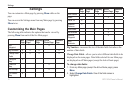
Settings
Map Tab > Points Subheading
Text—sets the screen size of the name of the waypoint, the active
route, the marine navaid, or the geo point on the Map page and
the Highway page.
Zoom—sets the maximum scale at which the feature should
appear on the Map page.
Map Tab > Other Subheading
Acc. Circle (Accuracy Circle)—represents the approximate
accuracy of the unit. Your location is indicated in the center of
the circle.
Heading Line—draws an extension line from the bow of the
boat in the direction of travel.
Bearing Line—shows the bearing from your current location
to a destination waypoint. Selecting a distance sets the scale at
which the bearing line will appear on the screen.
Course Line—shows a navigation line from the point where
navigation was initiated to a destination waypoint. Selecting a
distance sets the scale at which the course line will appear on the
screen.
•
•
•
•
•
•
Using the Systems Tab
From any Main page, press Menu twice and highlight Page.
Beeper—selects when the unit makes audible sounds.
Speed Filter—averages the speed readings of your boat over
a period of time for smoother speed values. You can select
Auto, or select On to specify the number of seconds you want
the lter to average.
Language—selects the system language.
System Mode—allows you to select simulator mode
(page 23) or normal mode.
Using the Units Tab
The Units tab allows you set units of measure for various values, the
map datum, and the heading reference.
From any Main page, press Menu twice and highlight Units.
Position Format—changes the coordinate style in which a given
location reading appears. Do not change the position format
unless you are using a map or chart that species a different
position format.
Map Datum—changes the coordinate system in which the map
is structured. Do not change the map datum unless you are using
a map or chart that species a different map datum.
•
•
•
•
•
•