


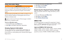

GPS 152H Owner’s Manual 19
Settings
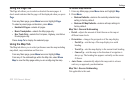
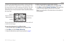
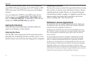
The top of the screen displays the tide station. The top of the chart
shows a 24-hour block of local time (LCL) for your position, with
the reported station time (STA) appearing at the bottom. The solid,
light vertical lines are in 4-hour increments, and the light, dotted
vertical lines are in 1-hour increments. A dark, vertical line indicates
the current time.
Maximum tide level
Minimum tide level
Present tide level
Present time
High tide
Low tide
The four data elds below the chart indicate event times and levels
at which the tide changes.
To view tide information for a different date:
1. From any Main page, press Menu twice and highlight Tide.
2. Press Menu, and select Modify Station Opt.
3. Select the Date eld and enter text as described on page 2.
To select the tide station nearest your location:
1. From any Main page, press Menu twice and highlight Tide.
2. Press Menu, and select Nearest Tide Station. The name of the
nearest tide station appears along the top of the screen.
Note: You must be within 100 nautical miles of a tide station to
use this feature.