


Deleting All Saved Tracks
Select Info > User Data > Clear User Data > Saved
Tracks.
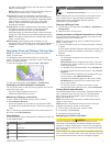
Retracing the Active Track
The track currently being recorded is called the active track.
1
Select Info > User Data > Tracks > Follow Active Track.
2
Select an option:
• Select the time the active track began.
• Select Entire Log.
3
Review the course indicated by the colored line.
4
Follow the colored line, steering to avoid land, shallow water,
and other obstacles.
Clearing the Active Track
Select Info > User Data > Tracks > Clear Active Track.
The track memory is cleared, and the active track continues
to be recorded.
Managing the Track Log Memory During Recording
1
Select Info > User Data > Tracks > Active Track Options.
2
Select Record Mode.
3
Select an option:
• To record a track log until the track memory is full, select
Fill.
• To continuously record a track log, replacing the oldest
track data with new data, select Wrap.
Configuring the Recording Interval of the Track Log
You can indicate the frequency at which the track plot is
recorded. Recording more frequent plots is more accurate but
fills the track log faster. The resolution interval is recommended
for the most efficient use of memory.
1
Select Info > User Data > Tracks > Active Track Options >
Interval > Interval.
2
Select an option:
• To record the track based on a distance between points,
select Distance > Change, and enter the distance.
• To record the track based on a time interval, select Time
> Change, and enter the time interval.
• To record the track plot based on a variance from your
course, select Resolution > Change, and enter the
maximum error allowed from the true course before
recording a track point.
Synchronizing User Data Across the Garmin
Marine Network
NOTICE
Before you synchronize the user data across the network, you
should backup your user data to prevent possible data loss. See
Backing Up Data to a Computer.
You can share waypoints, tracks, and routes with all compatible
devices connected to the Garmin Marine Network (Ethernet)
automatically.
NOTE: This feature is not available on all models.
Select Settings > Preferences > User Data Sharing > On.
If a change is made to a waypoint, track, or route on one
chartplotter, that data is synchronized automatically across all
chartplotters on the Ethernet network.
Deleting All Saved Waypoints, Routes, and
Tracks
Select Info > User Data > Clear User Data > All > OK.
Navigation with a Chartplotter
CAUTION
If your vessel has an autopilot system, a dedicated autopilot
control display must be installed at each steering helm in order
to disable the autopilot system.
The Auto Guidance feature is based on electronic chart
information. That data does not ensure obstacle and bottom
clearance. Carefully compare the course to all visual sightings,
and avoid any land, shallow water, or other obstacles that may
be in your path.
NOTE: Auto Guidance is available with premium charts, in
some areas.
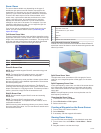
NOTE: Mariner's Eye 3D and Fish Eye 3D chart views are
available with premium charts, in some areas.
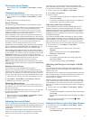
NOTE: The offshore Fishing chart is available with premium
charts, in some areas.
To navigate, you must choose a destination, set a course or
create a route, and follow the course or route. You can follow
the course or the route on the Navigation chart, Fishing chart,
Perspective 3D chart view, or Mariner’s Eye 3D chart view.
Basic Navigation Questions
Question Answer
How do I make the chartplotter
point me in the direction in
which I want to go (bearing)?
Navigate using Go To. See Setting
and Following a Direct Course Using
Go To.
How do I make the device
guide me along a straight line
(minimizing cross track) to a
location using the shortest
distance from the present
location?
Build a single-leg route and navigate it
using Route To. See Creating and
Navigating a Route From Your
Present Location.
How do I make the device
guide me to a location while
avoiding charted obstacles?
Build a multi-leg route and navigate it
using Route To. See Creating and
Navigating a Route From Your
Present Location.
How do I make the device
steer my automatic pilot?
Navigate using Route To. See
Creating and Navigating a Route From
Your Present Location.
Can the device create a path
for me?
If you have premium maps that
support Auto Guidance and are in an
area covered by Auto Guidance,
navigate using Auto Guidance. See
Setting and Following a Course Using
Auto Guidance.
How do I change the Auto
Guidance settings for my
boat?
See Auto Guidance Line
Configurations.
Destinations
You can select destinations using various charts and 3D chart
views or using the lists.
Searching for a Destination by Name
You can search for saved waypoints, saved routes, saved
tracks, and marine services destinations by name.
1
Select Info > Services > Search by Name.
2
Enter at least a portion of the name of your destination.
3
If necessary, select Done.
The 50 nearest destinations that contain your search criteria
appear.
4
Select the destination.
Selecting a Destination Using the Navigation Chart
From the Navigation chart, select a destination.
10 Navigation with a Chartplotter