


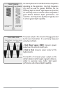
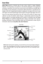

GPS uses a constellation of 24 satellites that continually
send radio signals to the earth. Your present position is
determined by receiving signals from up to 16 satellites
and measuring the distance from the satellites.
All satellites broadcast a uniquely coded signal once per
second at exactly the same time. The GPS receiver on
your boat receives signals from satellites that are visible
to it. Based on time differences between each received
signal, the GPS receiver determines its distance to each
satellite. With distances known, the GPS receiver
mathematically triangulates its own position. With
once per second updates, the GPS receiver then
calculates its velocity and bearing.
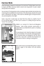
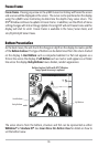
The GPS Receiver included with your 300 Series™ Fishing System, allows you to combine
easy-to-use FishingGPS™ chartplotter and navigation capabilities with advanced
fishfinding. The following GPS functionality is currently supported by the 300 Series™
Fishing System:
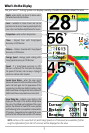
• View current position
• View current track (breadcrumb trail)
• View precision speed and heading from your GPS receiver
• Save tracks, waypoints and routes
• Travel a route and navigate from one waypoint to the next.
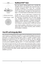
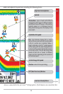
Your unit also comes with a built-in UniMap™ with a more detailed map of North
America (Domestic models) or a more detailed map of Europe and Southeast Asia,
including Australia and New Zealand (International models).
Your 300 Series™ uses the GPS Receiver to determine the position of the boat
automatically, and uses the zoom level settings on a particular view to select the best
chart to display. See Viewing Cartography for more information.
4