


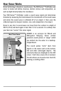

5
The following GPS functionality is currently supported by your Fishfinder when
it is connected to the included GPS receiver:
• View current position
• View current track (breadcrumb trail)
• View precision speed and heading from your GPS receiver
• Save tracks, waypoints and routes
• Travel a route and navigate from one waypoint to the next.
Your Fishfinder supports Navionics® Gold, HotMaps™ and HotMaps™Premium on
MMC or SD card media.
NOTE: Your Fishfinder does not support Navionics® Classic Charts, only Navionics® Gold,
HotMaps™, and HotMaps™ Premium.
Your unit also comes with a built-in UniMap™ with a more detailed map of
North America (Domestic models) or a more detailed map of Europe and
Southeast Asia, including Australia and New Zealand (International models).
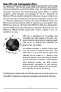
Your Fishfinder uses the GPS Receiver to determine the position of the boat
automatically, and uses the zoom level settings on a particular view to select
the best chart to display. See Viewing Cartography for more information.