


8
The other key GPS use for MMCs is storage of special high-detail, cus-
tom maps, which you can produce on your computer with our MapCre-
ate software. These MapCreate custom maps contain much greater de-
tail than the basic background map. These Custom Map Files (file
format *.lcm) can also be shared between LMS-480s, other Lowrance
GPS or sonar/GPS units and personal computers. (For example, the
exact same MMC, custom map files and GPS data files can be used in-
terchangeably between your gimbal-mounted LMS-480 and the hand-
held iFINDER GPS receiver.)
LMS-480 automatically reads Custom Map Files directly from the
MMC or SDC. To use a custom map, all you need to do is slide an MMC
containing a map into the unit.
Introduction to GPS and WAAS
Well, now you know the basics of how LMS-480 does its work. You
might be ready to jump ahead to Section 2, Installation & Accessories,
on page 13, so you can mount your unit and plug in the power. Or you
might want to see how our text formatting makes the manual tutorials
easy to skim. If that's the case, move on to "How to Use This Manual"
on page 10. But, if you want to understand the current state of satellite
navigation, look over this segment describing how GPS and its new
companion WAAS work together to get you where you're going.
The Global Positioning System (GPS) was launched July 17, 1995 by
the United States Department of Defense. It was designed as a 24-
hour-a-day, 365-days-a-year, all weather global navigation system for
the armed forces of the U.S. and its allies. Civilian use was also avail-
able at first, but it was less accurate because the military scrambled
the signal somewhat, using a process called Selective Availability (SA.)
GPS proved so useful for civilian navigation that the federal govern-
ment discontinued SA on May 2, 2000, after the military developed
other methods to deny GPS service to enemy forces. Reliable accuracy
for civilian users jumped from 100 meters (330 feet) under SA to the
present level of 10 to 20 meters (about 30 to 60 feet.)
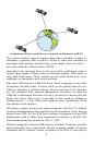
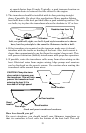
Twenty-four satellites orbit 10,900 nautical miles above the Earth,
passing overhead twice daily. A series of ground stations (with precisely
surveyed locations) controls the satellites and monitors their exact loca-
tions in the sky. Each satellite broadcasts a low-power signal that identi-
fies the satellite and its position above the earth. Three of these satellites
are spares, unused until needed. The rest virtually guarantee that at
least four satellites are in view nearly anywhere on Earth at all times.