


6
Y1-03-0222 Rev. C
In order to meet carriage requirements for Class A and Class B AIS systems, dedicated GPS and VHF antennas
must be fit to the transponders. ACR has included GPS and VHF antennas that have been specifically
designed, tested and approved for use with the Nauticast™-B. ACR Electronics Inc. does not recommend or
support using other antennas or sharing data information from existing shipboard installations.
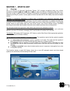
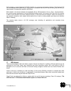
Class B AIS transponders will transmit data to other AIS equipped vessels and shore base stations. Static data
typically identifies the vessel and does not change (i.e. MMSI, Vessel Name). Dynamic data is voyage specific
and will change during the normal operation of the vessel.(i.e. Speed Over Ground, Position, Heading).
In order to complete the programming of your AIS transponder, documentation of your vessel‟s identity needs to
be made available. This would be a good time to update any information that is inaccurate in the MMSI data
base or with your ship‟s radio station license. These databases should be reviewed periodically to make sure
the information is accurate including your emergency contact information.
Per FCC rules (United States users only) the static data can only be programmed into an AIS Transponder by
the vendor or qualified personnel. Once the static data is programmed into an AIS Transponder it can only be
corrected by ACR Electronics. Please check that the static data are entered carefully. If the static data are
incorrectly programmed the transponder will need to be returned to ACR for factory reset.
Information transmitted from vessels that have a Class A AIS transponders on-board include:
• Name of Vessel
• Destination
• Size of Vessel
• Vessel Dimensions
• Speed (SOG)
• Call Sign
• ETA
• Draft
• Position
• Course (COG)
• Type of Vessel
• Status
• MMSI Number
• Navigational Status
• Heading
• Cargo
• Rate of Turn
• IMO Number
Information transmitted from vessels that have a Class B AIS transponders on-board include:
• Name of Vessel
• Vessel Dimensions
• Speed (SOG)
• Type of Vessel
• Position
• Heading
• MMSI Number
• Course (COG)
• Call Sign
NOTE: The marine AIS system uses position information derived from networks such as the Global Positioning
Satellite (GPS) or the Global Navigation Satellite System (GLONASS) to determine the location of the AIS unit
and thus the vessel to which it is fitted. The Nauticast™-B AIS utilizes the GPS satellite network.
It is desirable wherever possible therefore to verify both your vessel‟s AIS derived position data and other
vessels‟ AIS derived position data with visual or radar based observations.
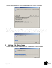
SECTION 2 - INSTALLATION
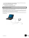
1. Product contents
Before proceeding with the installation of the Nauticast™-B AIS, please verify that the content of the box
includes the following:
Nauticast™-B AIS transponder
Data/Power cable
Mounting hardware (4 self tapping screws)
Strain relief cable straps (3)
VHF antenna (dedicated for AIS use only) with connection cable
GPS antenna (dedicated for AIS use only) with connection cable
Nauticast™-B AIS Product Support Manual
Nauticast™-B Mounting Template
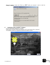
Link2AIS™ Software CD
Link2AIS™ Software User Guide
Warranty card
NOTE: For information reporting
intervals, see Specifications appendix