


96
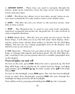
Navigation Page, backtracking a trail while creating a new trail.
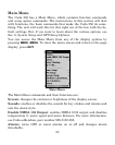
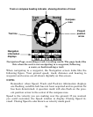
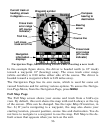
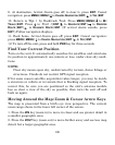
In the example figure above, the driver is headed north (a 12º track)
toward a waypoint 12º (bearing) away. The cross track error range
(white corridor) is 0.20 miles either side of the course. The driver is
headed toward a waypoint which is 0.22 miles away.
The Navigation Page has its own menu, which is used for some ad-
vanced functions and for setting various options. To access the Naviga-
tion Page Menu, from the Navigation Page, press
MENU.
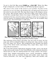
Full Map Page
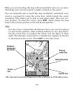
The Full Map screen shows your course and track from a bird's-eye
view. By default, this unit shows the map with north always at the top
of the screen. (This can be changed. See the topic Map Orientation, in
Sec. 8.) If you're navigating to a waypoint, the map also shows your
starting location, present position, course line and destination. You do
not have to navigate to a waypoint to use the map. Full Map is the de-
fault screen that appears when you turn on the unit.
Navigation
information
displays
Bearing
arrow
Cross track
error range
(off course
indicator)
Course line
Waypoint symbol
Current track or
heading, shown
in degrees
Compass
bearing to
destination
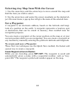
Trail line
Left cross
track error line
Cross track
error range
(off course
indicator)