


6
chart. The sonar's microprocessor calculates the time lapse between the
transmitted signal and echo return to determine the distance to the
object. The whole process repeats itself several times each second.
Your unit can record a log of the sonar signals that scroll across the
screen and save them to the MMC memory card. (These recordings are
also called sonar charts or sonar graphs.) You can replay this sonar log
in the unit using the Sonar Simulator function, or play it back on a per-
sonal computer using our free Sonar Viewer or product emulator. The
viewer and emulator are available for download from the Eagle web
site, www.eaglesonar.com.
You can save several different sonar log files, erase 'em and record new
ones, over and over again. The size of your sonar recordings is only
limited by the free space available on your MMC.
How GPS Works
You'll navigate faster and easier if you understand how the unit scans
the sky to tell you where you are on the earth – and where you're going.
(But if you already have a working understanding of GPS receivers and
the GPS navigation system, skip on ahead to Section 2, Installation &
Accessories on page 13. If you're new to GPS, read on.
Think of your unit as a small but powerful computer. The unit includes
a keypad and a screen with menus so you can tell it what to do. The
screen also lets the unit show your location on a moving map, as well as
point the way to your destination.
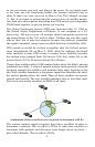
This gimbal-mounted unit uses an internal antenna and receiver,
which makes the system work like your car radio. But instead of your
favorite dance tunes, this receiver tunes in to a couple of dozen GPS
satellites circling the earth. (It will also listen to WAAS satellites in
orbit, but we will delve into that in the segment introducing you to GPS
and WAAS.)
Your unit listens to signals from as many satellites as it can see above
the horizon, eliminates the weakest signals, then computes its location
in relation to those satellites. Once the unit figures its latitude and lon-
gitude, it plots that position on the moving map shown on the screen.
The whole process takes place several times a second!
The performance doesn't stop there. Stored in the permanent memory
of each unit is a basic background map of the entire world. We lock it in
here at the factory — you can not change or erase this map.
The background map is suitable for many navigation chores, but for
maximum accuracy and much more detail, you need our optional map-