


3. PLOTTER OPERATION
3-54
3.11.8 Grounding alarm (C-MAP specification)
The grounding alarm feature continuously scans the electronic chart data in front of the boat
to detect charted rocks, shoals, obstructions and land areas that could pose a threat if the
vessel were to continue along its current course. The area searched is user-definable and is
identified by a red triangle on the screen.
Note: This function only checks objects that appear on the chart and is therefore limited by
the accuracy of the original source material from which the electronic charts where
produced.
1. Press the ALARM key to open the alarm menu.
2. Choose GROUNDING ALARM from page 2 of the ALARM menu.
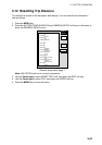
3. Press the EDIT soft key to show the grounding alarm window.
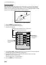
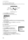
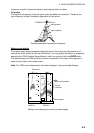
GROUNDING ALARM
▲
{ ON 0.500 ft
~ OFF
▼
Grounding alarm window
4. Select ON.
5. Use the Trackball and the alphanumeric keys to enter depth setting: Operate the
Trackball to set depth. Set shallow depth for shallow waters.
6. Press the ENTER soft key or push the ENTER knob to register setting.
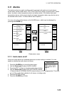
7. Choose GROUNDING ALARM RANGE and push the ENTER knob.
GROUNDING ALARM RANGE
0 .250 nm
8. Use the Trackball and alphanumeric keys to enter alarm range, that is, how far ahead
to look for possible grounding situations.
9. Press the ENTER soft key.
10. Press the ALARM key to finish.