


3. PLOTTER OPERATION
3-16
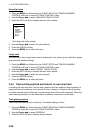
C-map, port service displa
y
Tide information
The C-MAP NT chart card provides for calculation of the tide heights for any date.
Additionally it displays the times of sunrise and sunset.
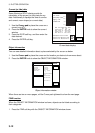
1. Use the Cursor pad to place the cursor on a Tide icon (
T
).
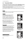
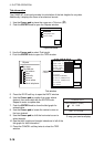
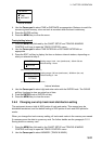
2. Push the ENTER knob to open the Objects window.
OBJECTS
Tide height
Cartographic area
Source of data
Objects window
3. Use the Cursor pad to select Tide height.
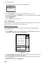
4. Push the ENTER knob to open the TIDE window.
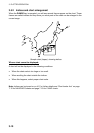
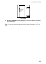
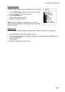
Objects
Port area
Port/Marine
Fuel station
Water
Electricity
Showers
Pubric toilets
Pubric telephone
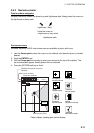
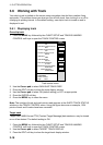
34 24. 3456 N 359.9 NU
124 24. 3456 W 59.9kt 024nm
+
Time: 04:35L
Height: 0.45ft
Draught: 0.65ft
28/10/98 -
UTC
05
43° 32.860N
010° 18.022E
Port information
LIVORNO (LEGHORN)
High Water(max)
0.86ft(13:30 L)
Low Water(min)
0.35ft(21:00 L)
Sunrise
07:52L
Sunset
16:53 L
0.86
0.74
0.61
0.48
0.35
048
12
162024
RETURN
DATE
V
ertical
C
ursor
TIDE
Tide window
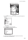
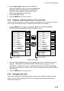
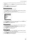
5. Press the DATE soft key to open the DATE window.
6. Use the Cursor pad to position the cursor where
desired, then enter date with the ENTER knob.
Repeat to enter complete date.
7. Push the ENTER knob to show the tidal graph for
entered date.
8. Use the Cursor pad to locate the vertical cursor on
the hour desired.
9. Use the Cursor pad to shift the horizontal cursor to
select draught.
10. See the time, height and draught indications in left of the
tide graph for tide information.
11. Press the CANCEL soft key twice to close the TIDE
window.
CHANGE DATE
(DAY. MONTH. YEAR)
2 8. 03. 2005
LIMIT: 31.12.2099