


5. AIS OPERATION
5-4
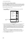
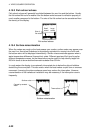
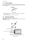
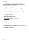
5.4 Activating Targets
Use the trackball to place the cursor on the sleeping AIS target (indicates only the presence
of a vessel equipped with AIS in a certain location) you wish to activate; that is, know more
about a vessel’s motion.
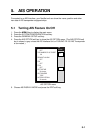
Heading
line*2
SOG and
COG vector
*1
Turning
direction
Activated target
*1: Vector shows STW (speed thru water) and CSE (course) when water tracking mode is
selected at the radar.
*2: If there is no heading data, the line points in direction of COG.
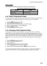
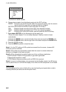
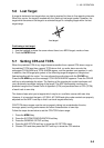
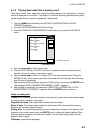
5.5 Displaying Target Data
Plotter display: Place the cursor on an AIS target symbol.
Radar display: Place the cursor on an AIS target symbol. Press the TARGET soft key then
the TARGET INFO soft key.
Activated target selected for data display (radar display only)
MMSI 123456789
NAME QUEEN ELIZABETH
COG 359
°
SOG 23.2kt
CPA 2nm TCPA 12:35
BRG 359.4 RNG 10.8nm
BEAM 32m LENGTH 294m
MMSI No.
Ship's Name
Course over Ground*, Speed over Ground
#
CPA and TCPA
Bearing, Range
Beam, Length
* = CSE (course) when water tracking mode is selected at radar.
# = STW (speed thru water) when water tracking mode is selected at radar.
AIS target data display