


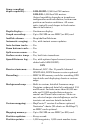
4
Sonar sounding
depth capability: ........... LMS-320DF: 2,500 feet/762 meters.
LMS-320: 1,000 feet/305 meters.
(Actual capability depends on transducer
configuration and installation, bottom com-
position and water conditions. All sonar
units typically read deeper in fresh water
than in salt water.)
Depth display:................ Continuous display.
Graph recording:........... Up to 256 MB on one MMC (or SD) card
Audible alarms: ............. Deep/shallow/fish/zone.
Automatic ranging:....... Yes, with instant screen updates.
Auto bottom track:........ Yes
Zoom bottom track: ...... Yes.
Split-screen zoom:......... Yes.
Surface water temp: ..... Yes, built into transducer.
Speed/distance log:....... Yes, with optional speed sensor (sensor in-
cluded with LMS-320DF.)
GPS
Receiver/antenna:......... External; LGC-12w 12 parallel channel
GPS/WAAS; DGPS beacon receiver optional.
Recording:........................MMC & SD memory cards for recording GPS
trip details and displaying charts or custom
maps.
Background map:.......... Built-in custom, detailed Lowrance map.
Contains: enhanced detail of continental U.S.
and Hawaii. Includes more than 60,000 nav
aids and 10,000 wrecks/obstructions in
coastal and Great Lakes waters. Metro ar-
eas, selected major streets/highways and in-
terstate exit services details included.
Custom mapping: .......... MapCreate version 6 software optional;
Navionics
charts (XL charts or HotMaps)
on MMC cards optional.
Mapping memory:......... Up to 256 MB on one MMC (or SD) card.
Position updates: .......... Every second.
Position points: ............. 1,000 waypoints; 1,000 event marker icons.