


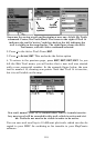

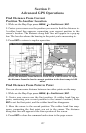

122
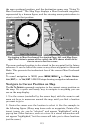
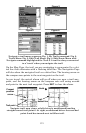
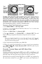
Navigate trail, navigation page (compass rose) views: at left, driver is
northbound heading straight toward trail point 6; bearing arrow
shows the trail point is due north (straight ahead.) At right, driver has
reached trail point 6 and must turn west to follow the trail. Arrival
alarm goes off and bearing arrow swings around to say turn left (west),
toward the next waypoint, trail point 7. LMS-320 now shows naviga-
tion information to point 7, which is 1.99 miles away.
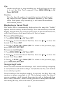
Navigate a Back Trail (backtrack, or reverse)
1. Press
MENU
|
MENU
|↓ to
M
Y
T
RAILS
|
ENT
.
2. Press ↓|↓ to enter the Saved Trail list, then use ↑ or ↓ to select the
desired Trail Name|
ENT
.
3. Press → to
D
ELETE
T
RAIL
|↓ to
N
AVIGATE
|
ENT
.
4. Press ↓ to
N
AVIGATE
|→ to
R
EVERSE
|
ENT
|← to
N
AVIGATE
|
ENT
. The unit
begins showing navigation information along the trail, in reverse.
NOTE:
If you are already located at or near the end of your trail, the arri-
val alarm will go off as soon as you hit Enter. Just press
EXIT
to
clear the alarm and proceed.
5. Now, begin moving and follow your LMS-320.
6. When you reach your destination, be sure to cancel your navigation:
press
MENU
|
MENU
|↓ to
C
ANCEL
N
AVIGATION
|
ENT
. LMS-320 asks if you're
sure; press ←
|
ENT
.
Transfer Custom Maps and GPS Data Files
Custom Maps:
Custom maps work only from the MMC card or SDC card. When a card
containing a Custom Map File is loaded into the unit, LMS-320 auto-
matically loads the map into memory when the unit is turned on.
Instructions for copying Custom Map Files to an MMC are contained in
the instruction manual for your MMC card reader and MapCreate 6
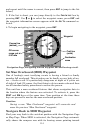
Trail
waypoint
symbol
Track or compass heading indicator
Arrival
alarm
Course
line made
from trail
Cross track
error range
(off course
indicator)
Bearing
arrow