


130
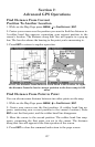
Routes
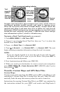
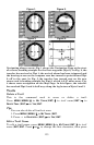
A route is a series of waypoints, linked together in an ordered sequence,
that's used to mark a course of travel. You can visualize a route as a
string of beads: The beads represent waypoints and the string repre-
sents the course of travel connecting waypoint to waypoint.
The course from one waypoint to the next is a leg; routes are composed
of one or more legs. The legs of all GPS routes are based on straight
lines between waypoints.
A route provides the automatic capability to navigate through several
waypoints without having to reprogram the unit after arriving at each
waypoint. Once programmed into the GPS unit, a route provides the
option of navigating forward through the route waypoints or in reverse
order (you can even begin navigating in the middle of a route!)
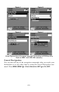
Create and Save a Route
You have the option of creating and editing a route in the unit, or you
can make a route on your computer with our MapCreate 6 software.
PC-created Routes
MapCreate is the easiest method for preparing a route, simply because
your PC's larger screen, keyboard and mouse are easier to manipulate
than the gimbal-mounted LMS-320.
To load a MapCreate route into LMS-320, follow instructions in Map-
Create's manual for creating a route and saving it as part of a GPS
Data File (file format *.usr). Copy the GPS Data File to an MMC and
insert the MMC in LMS-320. (See Sec. 2 for instructions on installing
MMCs. To load the GPS Data File into LMS-320 memory, see the entry
on Transfer Custom Maps & GPS Data Files in Sec. 6, Basic GPS Op-
erations.)
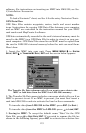
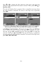
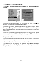
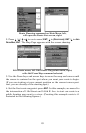
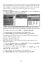
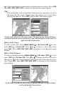
Routes Created in LMS-320
You can create a route by selecting existing waypoints from the way-
point list or you can set a series of route waypoints on the map with
cursor arrows and the Enter key. In this example, we'll create a route
from the map.
1. From the
N
AVIGATION
P
AGE
, press
MENU
|
ENT
or from the
M
AP
P
AGE
,
press
MENU
|
MENU
|↓ to
R
OUTE
P
LANNING
|
ENT
.