


70
Menus for changing coordinate system used to display positions.
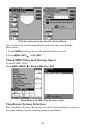
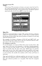
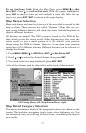
To get to Coordinate System Selection:
1. Press
MENU
|
MENU
|↓ to
GPS S
ETUP
|
ENT
.
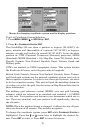
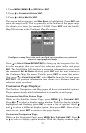
2. Press ↓ to
C
OORDINATE
S
YSTEM
|
ENT
.
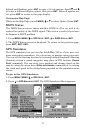
This IntelliMap 320 can show a position in degrees (36.14952°); de-
grees, minutes and thousandths of a minute (36° 28.700'); or degrees,
minutes, seconds and tenths of a second (36° 28' 40.9"). It can also show
position in: UTM (Universal Transverse Mercator) projection; MGRS
(Standard); MGRS (Standard + 10); Map Fix; Loran TD; British, Irish,
Finnish, German, New Zealand, Swedish, Swiss, Taiwan, Greek and
Military grids.
UTM's are marked on USGS topographic charts. This system divides
the Earth into 60 zones, each 6 degrees wide in longitude.
British, Irish, Finnish, German, New Zealand, Swedish, Swiss, Taiwan,
and Greek grid systems are the national coordinate system used only in
their respective countries. In order to use these grid systems, you must
be in the respective country. This unit will pick the matching datum for
you when you select the grid. See the entry on Map Datum Selection for
more information.
The military grid reference system (MGRS) uses two grid lettering
schemes, which are referred to as standard and standard + 10 MGRS
on this unit. Your position and datum in use determines which one to
use. If you use standard, and your position is off significantly, then try
the alternate.
NOTE: When the position format is changed, it affects the way all posi-
tions are shown on all screens. This includes waypoints.
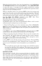
To change the coordinate system, press
ENT
while
C
OORDINATE
S
YSTEM
is
highlighted. Press the ↑ or ↓ arrow keys to highlight the desired for-
mat. Press
ENT
to select it. Press
EXIT
to erase the menus.