


175
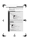
How to operate the AREA SHOT function (U.S.A. only)
X
Map data
The map data used by the deck was created based on information
provided by Tele Atlas and Geographic Data Technology.
When using the map data, be aware actual road conditions and
obey traffic rules.
Copying, publishing or using maps in electronic media without
express written consent is forbidden.
GPS (Global Positioning System)
Developed and operated in the United States, GPS(Global
Positioning System), is a system that locates current position
(longitude and latitude) using radio waves beamed to earth from 3
or 4 GPS satellites.
GPS information may not be available under the following
circumstances:
●When GPS satellite radio waves are interrupted by buildings,
tunnels, elevated roads, etc.
●When radio waves are interrupted by objects on or near the GPS
antenna.
●In some instances, wave transmission is interrupted by the U.S.
tracking control center during maintenance or upgrades.
●When a digital cellular phone (1.5 GHz) is used near a GPS
antenna.
● Make sure to follow the actual traffic regulations when driving.
● Driving your vehicle while only following guidance point
instructions may lead to traffic violations and cause accidents.
●
Do not modify this system for use other than that specified herein.
Also, do not deviate from the installation procedures described
herein, ECLIPSE will not be held liable for damages including, but
not limited to serious injury, death or property damage resulting
from installations that enable unintended operation.
CD8455_10_E.fm 175 ページ 2004年12月16日 木曜日 午後6時4分