


5
How GPS and Cartography Work
Your 700 Series™ Fishing System also supports GPS and chartplotting, and uses GPS and sonar
to determine your position, display it on a grid, and provide detailed underwater information.
The Global Positioning System (GPS) is a satellite navigation system designed and maintained
by the U.S. Department of Defense. GPS was originally intended for military use; however,
civilians may also take advantage of its highly accurate position capabilities, typically within
+/- 10 meters, depending on conditions. This means that 95% of the time, the GPS receiver
will read a location within 10 meters of your actual position. Your GPS Receiver also uses
information from WAAS (the Wide Area Augmentation System), EGNOS (the European
Geostationary Navigation Overlay Service), and MSAS (the MTSAT Satellite Augmentation
System) satellites if they are available in your area.
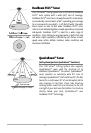
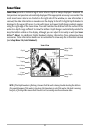
GPS uses a constellation of 24 satellites that continually send
radio signals to the earth. Your present position is determined
by receiving signals from up to 16 satellites and measuring the
distance from the satellites.
All satellites broadcast a uniquely coded signal once per
second at exactly the same time. The GPS receiver on your
boat receives signals from satellites that are visible to it.
Based on time differences between each received signal, the
GPS receiver determines its distance to each satellite. With
distances known, the GPS receiver mathematically
triangulates its own position. With once per second updates,
the GPS receiver then calculates its velocity and bearing.
The GPS Receiver included with your 700 Series™ Fishing System, allows you to cosmbine easy-to-
use FishingGPS™ chartplotter and navigation capabilities with advanced fishfinding. The
following GPS functionality is currently supported by the 700 Series™ Fishing System when it is
connected to the included GPS receiver:
• View current position
• View current track (breadcrumb trail)
• View precision speed and heading from your GPS receiver
• Save tracks, waypoints and routes
• Travel a route and navigate from one waypoint to the next.
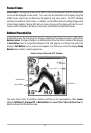
Your 700 Series™ supports Navionics® Gold, HotMaps™ and HotMaps™Premium on MMC or SD
card media.