


57
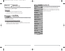
Lat/Lon Grid
Lat/Lon Grid allows you to display or hide a grid showing latitude
and longitude lines.
T
o chang
e the Lat/Lon Grid setting:
1. Highlight Lat/Lon Grid on the Navigation main menu.
2. Use the LEFT or RIGHT 4-WAY Cursor Control keys to change the Lat/Lon Grid setting.
(Hidden, Visible, Default = Hidden)
Spot Soundings
Spot Soundings allows you to display or hide spot soundings,
which are depth measurements shown on the chart.
NOTE: Spot Soundings are only available on optional-purchase MMC charts.
To change the Spot Soundings setting:
1. Highlight Spot Soundings on the Navigation main menu.
2. Use the LEFT or RIGHT 4-WAY Cursor Control keys to change the Spot Soundings setting.
(Hidden, Visible, Default = Hidden)
Shaded Depth
Shaded Depth allows you to change the depth used for shading
on the chart views.
T
o change the Shaded Depth setting:
1. Highlight Shaded Depth on the Navigation main menu.
2. Use the LEFT or RIGHT 4-WAY Cursor Control keys to change the Shaded Depth setting.
(Off, 1 to 60 Feet or 1 to 20 Meters [International Units Only], Default = 16 ft, 5 m)
North Reference
North Reference allows you to have bearings displayed with one
of two orientations: True North or Magnetic North.
T
o change the North Reference setting:
1. Highlight North Reference on the Navigation main menu.
2. Use the LEFT or RIGHT 4-WAY Cursor Control keys to change the North Reference setting.
(True, Magnetic, Default = True)
56
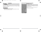
Chart Detail Level
Chart Detail Level allows you to select how much chart detail you
want displayed on the Navigation Views. Basic shows land areas, ports, obstructions and restricted
areas. Navigation shows navaids, landmarks, ferryways and navigation routes in addition to the
Basic information. Underwater shows depth contours, fishing areas, underwater wrecks, tides and
currents in addition to the Basic and Navigation information. All shows roads, buildings, railways,
and other notations in addition to the Basic, Navigation and Underwater information.
T
o chang
e the Chart Detail Level setting:
1. Highlight Chart Detail Level on the Navigation main menu.
2. Use the LEFT or RIGHT 4-WAY Cursor Control keys to change the Chart Detail Level
setting. (Basic, Navigation, Underwater, All, Default = All)
NOTE: Some chart details are only available on optional-purchase MMC charts.
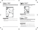
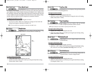
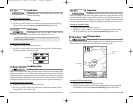
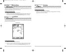
Map Borders
Map Borders allows you to display or hide map borders. A Map
Border indicates an area which contains a different map.
To change the Map Borders setting:
1. Highlight Map Borders on the Navigation main menu.
2. Use the LEFT or RIGHT 4-WAY Cursor Control keys to change the Map Borders setting.
(Hidden, Visible, Default = Hidden)
Map Borders
Map
Borders
M87_Man_531352-1_A.qxd 12/9/2004 3:28 PM Page 62