


mn100 Dual Digital Display
12
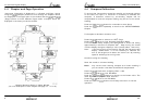
(p12) APP WIND Angle
The Actual Wind Angle with respect to the vessel as
measured by the Wind Transmitter.
(p13) TRUE WIND Speed
The True Wind Speed with respect to the vessel, calculated
by the instrument taking into account the vessels speed
through the water. Both Apparent Wind Speed, Angle and
Boat Speed must be available on the network for this
calculation.
(p14) TRUE WIND Angle
The True Wind Angle with respect to the vessel, calculated
by the instrument taking into account the vessels speed
through the water. Both Apparent Wind Speed, Angle and
Boat Speed must be available on the network for this
calculation.
(p15) MAG TWDIR
The Actual Wind Direction over the water, calculated by the
instrument taking into account the vessels speed through the
water and compass heading. Apparent Wind Speed, Direction
and Compass Heading must be available on the network for
this calculation.
(p16) BEAUF
The Actual Wind Speed over the water displayed using the
Beaufort scale, calculated by the instrument taking into
account the vessels speed through the water and compass
heading. Apparent Wind Speed, Direction and Compass
Heading must be available on the network for this
calculation.
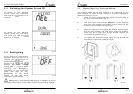
(p17 SHIFT HEAD/ LIFT
Indicates changes in the wind against a compass heading.
Spotting these wind changes is the key to fast sailing
upwind.
To set the mean wind angle:
1. If a Wind Transmitter is included in your Micronet system
then simply press the
button; (the current wind
direction is stored as the mean wind direction and displayed
for 5 seconds during which time the
and buttons
may be used to adjust the value.)
Setup and Calibration
25
Health Chapter
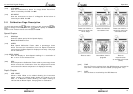
(s37) VER / NODES
Displays the instrument’s Software Version, battery level and
charge rate to assist in troubleshooting and fault finding. If
the instrument is the “Master” (the one used to switch on the
system) then the number of items (nodes) in the system will
be displayed. If the instrument is a “Slave” (was switched on
by the system) then the signal strength to the “Master” will
be displayed”
(s38) HULL SIGNL
Shows the signal strength and battery level of the Hull
Transmitter to assist in troubleshooting and fault finding.
(s39) WIND SIGNL (as above but for Wind Transmitter
information)
(s40) NMEA SIGNL (as above but for NMEA Interface information)
(s41 --)Further signal strength indications will be displayed if
available.