


mn100 Dual Digital Display
14
(p25) DTW
Distance To (active) Waypoint. The active Waypoint being
the one to which the GPS is currently navigating. When the
Waypoint has been named in the GPS the name will be
displayed (first five digits only).
(p25) DTW
Distance To (active) Waypoint. The active Waypoint being
the one to which the GPS is currently navigating. When the
Waypoint has been named in the GPS the name will be
displayed (first five digits only).
(p26) XTE
Cross Track Error as defined by the GPS Antenna.
(p27) ETA
Estimated Time of Arrival at the (active) Waypoint as
calculated by the GPS Antenna.
(p28) SEA
Current Sea Temperature as measured by the sensor in the
Speed Transducer.
(p29) TIMER
Countdown or elapsed time stopwatch.
Press and hold for 1 second the
button and use the
and buttons to set the required countdown time in
minutes, then press and hold for 1 second the
button to
prepare to start the countdown.
Press the
button quickly to start the countdown.
The instrument will sound a single beep each 30 seconds
until 1 minute remains when a beep will sound at 10 second
intervals. The final 10 seconds will count down with a beep
each second with “START” being indicated by a triple quick
beep at 0. The timer will automatically start to count the
elapsed time and this will continue until the
button is
pressed and held for one second.
At any stage a quick press of the
button will
resynchronise the timer to the nearest full minute and then
carry on the count down.
Example:
Press at 3mins 24secs the timer will reset to 3mins 0secs
Press
at 7mins 52secs the timer will reset to 8mins 0secs
Setup and Calibration
23
Wind Chapter
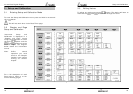
(s22) RESP Wnd
Sets the update period of the Wind display.
Auto/Slow/Medium/Fast
(s23) WIND (degrees)
Aligns the displayed Apparent Wind Angle with the Actual
Wind Direction with respect to the boat. See page 25 for
calibration.
(s24) WIND (speed)
Adds a percentage factor which corrects the information
from the Wind Transmitter and ensures the Apparent Wind
Speed is displayed correctly. See page 24 for calibration.
Compass Chapter
(s25) RESP HEAd
Sets the update period of the Compass display.
Auto/Slow/Medium/Fast
(s26) HDG (Mag/True)
Tells the instrument to display heading information in either
Magnetic or True format.
(s27) HDG (degrees)
Aligns the displayed heading with the Actual Magnetic
Heading of the boat. See page 26 for calibration.
(s28) VAR
Allows manual entry of local magnetic variation. This setting
is ignored if variation information is available from a GPS
source.
(s29) DEV
However carefully positioned the Compass Transducer is,
there is always the likelihood of errors being introduced by
the vessel and equipment. To remove errors it is necessary
to “Swing” the compass by turning the boat slowly until the
system can optimize the readings. Once the correction has
been completed the deviation correction value will be
displayed. See page 26 for calibration.