


GPS chartplotters Page 35
4. USING FIND SERVICES & MORE FUNCTION
With a C-MAP NT
+
C-CARD installed the chartplotter allows you to search for a Port Service,
Ports, Tide Stations, Wrecks, User Points, or GPS Coordinates.
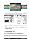
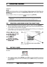
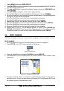
4.0 PORT SERVICES
With a C-MAP NT+ C-CARD installed, the chartplotter can find Port Services contained on
the map.
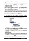
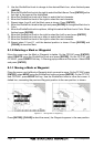
1. Press [MENU] and move the ShuttlePoint knob to select
FIND SERVICES & MORE.
2. Press [ENTER] or move the ShuttlePoint knob to the right.
3. Select
PORT SERVICE and press [ENTER] or move the ShuttlePoint knob to the right.
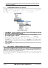
3. A popup window will be shown with the Port Services.
4. Move the ShuttlePoint knob to select the desired Service and press [ENTER].
5. Another popup window will show the name, distance and position of the Services closest
to your location.
6. Using the ShuttlePoint knob, highlight the desired Service and press [ENTER] which will
show the name and phone number of the Service.
7. Press [CLEAR] which will show the available Services at the location.
8. Press [CLEAR] to show the actual position of the Services.
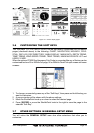
Figure 4.0 - Port Services
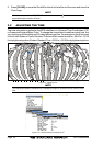
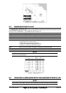
4.1 OTHER AVAILABLE SEARCHES
PORT Search and showing on the Chart Page the closest Port or search for a Port by name
TIDE STATIONS Search for the closest Tide Station and show the information of the tide station
WRECKS Search and show on the Chart Page for the closest Wrecks
OBSTRUCTIONS Search and show on the Chart Page for the closest Obstructions
USER POINTS Search and show on the Chart Page for the closest User Points (Marks or Waypoints)
COORDINATES Search and show on the Chart Page for GPS Coordinates