


GPS chartplotters Page 57
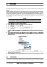
1. To change, press [MENU] and move the ShuttlePoint to select SETUP.
2. Press [MENU] and move the ShuttlePoint to select
GENERAL SETUP.
3. Press [ENTER] or move the ShuttlePoint knob down to highlight
WINDOW SETUP.
4. Press [ENTER] or move the ShuttlePoint knob down to highlight
CHART PAGE.
5. Select the desired window, HIGHWAY or COMPASS and press [ENTER] or move the
ShuttlePoint knob to the right.
6. Press [CLEAR] or move the ShuttlePoint knob to exit the menu and show the Chart Page.
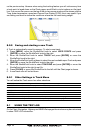
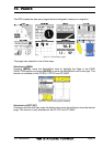
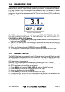
10.0.1 Additional Functions on Chart Page
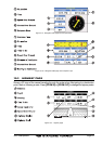
When on the Chart Page you will notice icons of Bouys, Towers, Lights, Wrecks, Tide
Stations and Port Icons. If the Cursor is moved over the top of these icons a popup window
will be shown with information about the icon.
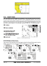
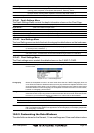
10.0.2 Turning Off Information on Icon Points
The GPS chartplotter allows you to select to see information on points, all items or to turn
this function off.
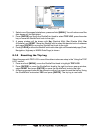
1. Press [MENU] and move the ShuttlePoint knob to highlight
SETUP.
2. Move the ShuttlePoint knob to highlight
GENERAL SETUP and press [ENTER].
3. Using the ShuttlePoint knob, highlight
AUTO INFO and move the ShuttlePoint to the
right.
4. Select the
Off, On Points, or On ALL and press [ENTER] or move the ShuttlePoint to
the Right.
5. Press [CLEAR] or move the ShuttlePoint knob to the left until the chart page appears.
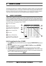
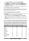
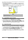
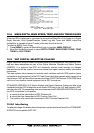
10.0.3 Setting up the Chart Page using the Map Setup Selection
With a NT
+
chart installed, the display of the chartplotter is visually communicated to
navigators as never before. To simplify the customization of the chart display, the map
settings are now re-organized in modes allowing the user to choose the preferred setting.
Pre-programmed settings are user selectable from Full, Simple, Fishing, Low and Custom.
The default setting is Custom. The custom selection allows the user to customize the chart
to user preferences. The chart below shows the selections for each mode:
Setting Full Simple Fishing Low
Names On On On Off
Nav-Aids US US US US
Light Sectors On Off Off Off
Attention Areas On On On Off
Tides & Currents On On On Off
Seabed Type On Off On Off
Ports & Services On On Off Off
Tracks & Routes On Off Off Off
Underwater Objects On Off Off Off
Depth Areas On On On Off
Depth Areas < 0005 0005 0005 0005
Depth Areas > 0030 0030 0030 0030
Depth Lines & Soundings On On On Off
Depth Lines & Soundings < 9999 0005 9999 0005
Depth Lines & Soundings > 0000 0000 0000 0000
Rivers & Lakes On On Off Off
Natural Features On Off Off Off