


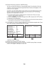

3-11
GEODETIC DATUM WGS-84
POSITION SMOOTHING 000 second (s)
SPD/CSE SMOOTHING 005 second (s)
LATITUDE OFFSET 0.000'N
LONGITUDE OFFSET 0.000'E
DISABLE SATELLITE - - - - - -
LATITUDE 45
°
35.000'N
LONGITUDE 125
°
00.000'W
ANTENNA HEIGHT 005 m
GPS FIX MODE 2D/3D
COLD START NO
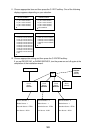
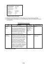
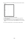
Installation wizard, GPS setup
40. Choose an item and press the C: EDIT soft key to show corresponding window.
41. Choose setting and then press the C: ENTER soft key. Refer to the table which follows
for description.
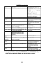
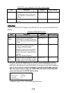
GPS SETUP menu description
Item Description Settings Default Setting
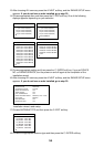
Geodetic
Datum
Your equipment is preprogrammed with
most of the major chart systems of the
world. Although the WGS-84 system,
the GPS standard, is now widely used
other categories of charts still exist.
Select the chart system used, not the
area where your boat is sailing.
Use the trackball
or ENTER knob
to select
appropriate
chart.
WGS-84
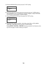
Position
Smoothing
When the DOP or receiving condition is
unfavorable, the GPS fix may change,
even if the vessel is dead in water. This
change can be reduced by smoothing
the raw GPS fixes. A setting between
000 to 999 is available. The higher
setting the more smoothed the raw
data, however too high a setting shows
response time to change in latitude and
longitude. This is especially noticeable
at high ship’ speeds. Increase the
setting if the GPS fix changes.
0-999 sec 0 sec (no position
smoothing)
(Continued on next page)