


8. CUSTOMIZING YOUR UNIT
8-9
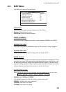
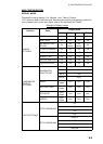
NAVIGATE
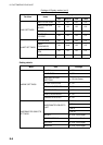
COMPASS
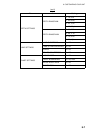
C-MAP WEATHER SERVICE
This function provides weather information. For further details, please ask your dealer.
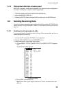
Item Settings
COORDINATE SYSTEM
Choose the coordinate display method among
ddd mm ss, ddd mm.mm, ddd mm.mmm and
ddd.ddddd for latitude, or TD.
MAP DATUM
Geodetic datum is a reference for geodetic sur-
vey measurements consisting of fixed latitude,
longitude and azimuth values associated with a
defined station of reference. You must have the
correct geodetic datum selected in your plotter
so that it will reference the correct point on the
chart for a given latitude and longitude.
Although WGS-84 is now the world standard,
other categories of charts still exist.
MAP ORIENTATION North Up, Course Up, Auto Course Up
MAP ORIENTATION RES
Sets the degree to re-draw the course on Auto
course-up mode. (Setting range: 5° to 60°)
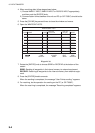
Item Settings
BEARINGS
Choose how to calculate bearing, Mag or True. True
bearing is a bearing measured using true North as the
reference direction, and it is calculated by the formula
True Bearing = Magnetic Bearing - Magnetic Variation.
Magnetic bearings are measured with magnetic north as
the reference direction. Select Mag when using a mag-
netic compass, True when using a gyrocompass.
VARIATION
The location of the magnetic north pole is different from
the geographical north pole. This causes a difference
between the true and magnetic north location. This differ-
ence is called magnetic variation, and varies with respect
to the observation point on earth. Your unit is prepro-
grammed with all the earth's magnetic variations. How-
ever, you may wish to enter variation manually to refine
accuracy by entering the magnetic variation referring to a
nautical chart.
CALIBRATION
Enters eight directions (N, N/E, E, S/E, S, S/W, W, N/W)
deviation values for magnetic compass.