


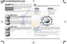
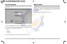

Nearest Port: The position and services information for the nearest port to your
present position will be displayed. Press the EXIT key to remove the information box
and the Bullseye Cursor will be centered over the port position. The Cursor Information
Boxes will indicate the distance and bearing to the port from your present position.
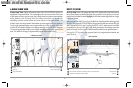
Nearest Tide Station: Tide information for the nearest tide station to your present
position will be displayed. This includes the position of the station and the times of the
high and low tides for today’s date. A tide graph is also displayed showing the rise and
fall of the tides for the 24 hour time period encompassing the date. You can change the
date to look at tide information before or after the date displayed by pressing the LEFT
or RIGHT Cursor key respectively. Press the EXIT key to remove the information box and
the Bullseye Cursor will be centered over the tide station position. The cursor
information boxes will indicate the distance and bearing to the tide station from your
present position.
Nearest Current Station: Current information for the nearest current station to your
present position will be displayed. This includes the position of the station and the
current changes for today. Two graphs are also presented that show the time, direction
and flow speed of the current changes for the 24 hour time period of today’s date. You
can change the date to look at current information before or after the date displayed
by pressing the LEFT or RIGHT Cursor key respectively. Press the EXIT key to remove the
information box and the Bullseye Cursor will be centered over the current station
position. The Cursor Information Boxes will indicate the distance and bearing to the
current station from your present position.
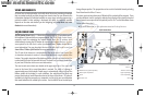
NAVIGATION
Use the 900 series™ to establish waypoints at areas of interest and to navigate to
those waypoints via a saveable route (representing the shortest intended distance
between waypoints). You can also view and save tracks, which represent the actual
path of the boat.
WAYPOINTS, ROUTES AND TRACKS
Waypoints are stored positions that allow you to mark areas of interest or navigation
points. Your 900 Series™ can store up to 3000 waypoints.
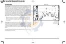
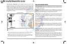
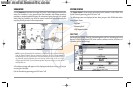
Waypoints, Routes and Tracks
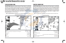
Depth TTG: Estimate of Trip Time to Destination Waypoint
1
6
HDG: Direction that boat is traveling
relative to North Reference
Speed of Boat
2
7
BRG: Direction to Destination Waypoint
Relative to North Reference
Waypoint
3
8
XTE: Cross Track Error. Distance of Boat
from Route
Route
4
9
DTG: Distance to Go to Waypoint
Off-Course Alarm Limits
5
10
Map Scale
11
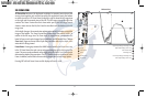
1
5
8
4
2
3
7
11
9
10
6
37
531374-1_A - 947 Man.qxd 2/15/2005 7:53 PM Page 42