


User Manual 17 Y1-03-0203 Rev.L
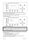
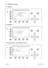
3.1.1 Own Vessel Data
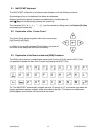
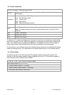
LAT:N 1°27.845'ExtSOG:34.6kn 05/26/06
LON:E 0°21.289'ExtCOG:173.0° 10:52:26
LAT:
Latitude
LON:
Longitude
Date:
The actual UTC - date (MM.DD.YY) and time (hh.mm.ss) are displayed on the top
right hand corner of this view.
IntGPS: 3D A/ ExtHDT:222° Reg6
IntGPS
Indicates normal or differential mode of GPS position.
2D or 3D: Indicates the precision of the GPS result.
Indicates the used position source:
intGPS. = internal GNSS receiver
extGPS = external GNSS receiver (sensors)
A/B: (A or B)
Indicates the last transmitting channel in use.
ExtHDT
True Heading
Reg:
then the vessel is traveling on high sea and is outside a predefined region.
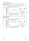
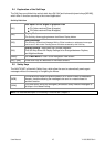
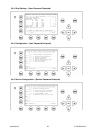
Message (SRM) Indication
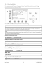
LAT:N 1
o
27.845'ExtSOG:34.6kn *3S
Queued safety related messages, e.g. *3S are displayed in the date field (instead of the date) in
the above example 3 Safety Related (3S) Messages are queued, and await viewing and handling
(acknowledgement or reply) in the Message Inbox History.
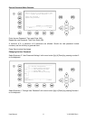
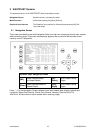
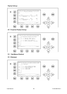
Alarm (ALR) and Text (TXT) Indication
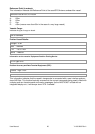
IntGPS: 3D /B Reg6 ! 3A 2T
Queued alarms or messages, e.g. ! 3A 2T are displayed in the 3
rd
line in the above example
3 (3A) Alarms and 2 (2T) Text Messages are in queue, and await viewing and handling
(acknowledgement and reaction).