


User Manual 38 Y1-03-0203 Rev.L
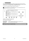
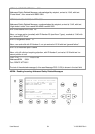
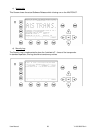
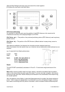
Own Vessel Position:
LAT : N 1°18.901' LON : E 0°12.345'
Heading and Rotation of own vessel:
Heading :77
o
ROT : +5.4°
IMO-Number and MMSI of own vessel:
IMO No. : 9100254 MMSI: 257530700
Name and CallSign of own vessel:
ShipName: MYLADY CS: D11233
Vessel Type:
Pilot vessel
Length and Beam of own vessel:
Length:310m Beam:73m
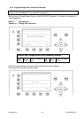
Reference Point (in meters):
This information indicates the Reference Point of the used GPS Antenna onboard the vessel.
RefPoint:A190 B120 C10 D>63m
A: 190m
B: 120m
C: 10m
D: >63m (means more than 63m in the case of a very large ship)
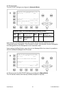
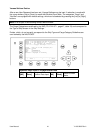
Vessels Cargo:
Indicates the type of cargo on board
N/A or harmless
Further Vessel Details:
Draught : 3.3m
Dest : HAWAII
ETA : 10/15 12:31
NavSt : Moored
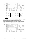
Information on the vessel’s Equipment Position Finding Device:
EPFDType: GPS
Position Accuracy and Data Terminal Equipment (DTE):
PosAcc :High <10m DTE :Available
The accuracy of the position is higher than 10 m (= High <10m), the opposite would be less than
10m (= Low >10m). This information indicates that the vessels Transponder is connected with a user
interface and can show AIS Data. This function basically ensures that the current Transponder being
used is fitted with a display and can therefore send and receive messages.
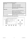
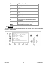
As the NAUTICAST is fitted with an integrated dis