


User Manual 20 Y1-03-0203 Rev.L
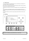
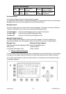
Reference Point (in meters):
This information indicates the Reference Point of the used GPS Antenna onboard the vessel.
RefPoint:A190 B120 C10 D<63m
A: 190m
B: 120m
C: 10m
D: <63m (means more than 63m in the case of a very large vessel)
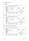
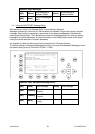
Vessels Cargo:
Indicates the type of cargo on board.
N/A or harmless
Further Vessel Details:
Draught : 3.3m
Dest : HAWAII
ETA : 10/15 12:31
NavSt : Moored
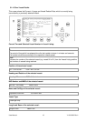
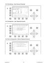
Information on the vessel’s Equipment Position Finding Device:
EPFDType: GPS
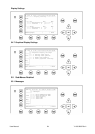
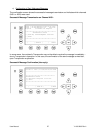
Position Accuracy and Data Terminal Equipment (DTE):
PosAcc :High <10m
DTE :Available
This information indicates that the vessels transponder is connected with a user interface and can
show AIS Data. This function basically ensures that the current transponder being used is fitted with
a display and can therefore send and receive messages. As the NAUTICAST is fitted with an