


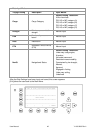

User Manual 46 Y1-03-0203 Rev.L
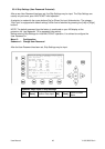
Sample:
Display:
CallSign = D11233
ShipName = M/V TUGELA
Length = 200m
Beam = 30m
RefPointExt = A170 B30 C15 D15m (location of the external GPS antenna)
RefPointInT = A171 B29 C0 D30m (location of the internal GPS antenna)
ShipType = Tug
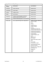
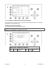
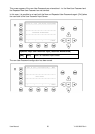
Setting of the external GPS antenna position:
A = 170m the distance from bow to the antenna
B= 30m the distance from the antenna to the stern
C = 15m the distance from the port side to the antenna
D = 15m the distance from the antenna to the starboard side
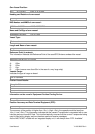
Move with Up/down keys to A:. Type 170
Type 30
Type 15,
Type 15,
The AIS calculates Length and Beam:
Len (A+B): 200m
Beam(C+D): 30m
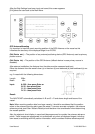
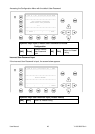
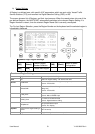
Setting of the internal GPS antenna position:
A = 171m the distance from bow to the antenna
B= 29m the distance from the antenna to the stern
C = 0m the distance from the port side to the antenna
D = 30m the distance from the antenna to the starboard side
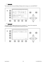
Move with Left/Right and Up/down keys to A:. Type 171
Type 29
Type 0,
Type 30,
The AIS calculates Length and Beam:
Len (A+B): 200m
Beam(C+D): 30m
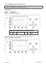
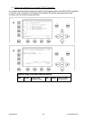
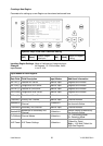
The calculated Length (A+B) and Beam (C+D) of external and internal GPS antenna position must
be the same value, other your entered distances are wrong and the AIS shows in the last line:
>>> ext/int ship length doesn't match
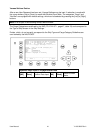
After correct settings of external and internal GPS antenna reference points the AIS allows to press
M5 - [Save]. to save your settings:
>>> DATA OK. PRESS M5 TO SAVE DATA <<<