


5
& Accessories on page 9. If you're new to GPS, read on, and you can later
impress your friends with your new-found knowledge.)
First, think of your unit as a small but powerful computer. (But don't
worry — we made this unit easy to use, so you don't need to be a com-
puter expert to find your way!) The unit includes a keypad and a screen
with menus so you can tell it what to do. The screen also lets the unit
show your location on a GPS plotter, as well as point the way to your
destination.
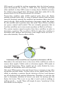
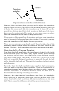
This unit uses an internal antenna/receiver module, which makes the
whole system work something like your car radio. But instead of your
favorite dance tunes, this receiver tunes in to a couple of dozen GPS
satellites circling the earth. (It will also listen in to the WAAS satellites
in orbit, but more about that in the upcoming segment introducing you
to GPS and WAAS.)
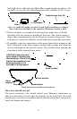
Your unit listens to signals from as many satellites as it can "see" above
the horizon, eliminates the weakest signals, then computes its location
in relation to those satellites. Once it figures its latitude and longitude,
the unit plots that position on the GPS screen. The whole process takes
place several times a second!
Another portion of the unit's onboard memory is devoted to recording GPS
navigation information, which includes waypoints, event marker icons,
trails and routes. This lets you look back the way you came, and retrace
your path. Think of this data storage like the hard drive memory in a
computer or a tape in a cassette tape recorder. You can save several dif-
ferent GPS data files, erase 'em and record new ones, over and over again.
Introduction to GPS and WAAS
Well, now you know the basics of how the unit does its work. You might
be ready to jump ahead to Section 2, Installation & Accessories, on page
13, so you can mount your unit and plug in the power. Or you might
want to see how our text formatting makes the manual tutorials easy to
skim. If that's the case, move on to "How to Use This Manual" on page
10. But, if you want to understand the current state of satellite naviga-
tion, look over this segment describing how GPS and its new companion
WAAS work together to get you where you're going.
The Global Positioning System (GPS) was launched July 17, 1995 by
the United States Department of Defense. It was designed as a 24-
hour-a-day, 365-days-a-year, all weather global navigation system for
the armed forces of the U.S. and its allies. Civilian use was also avail-
able at first, but it was less accurate because the military scrambled
the signal somewhat, using a process called Selective Availability (SA.)