


90
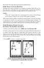
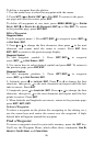
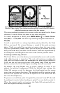
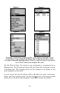
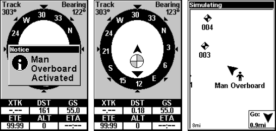
Navigating to Man Overboard: Navigation Page, left and center, and
Plotter Page, right. The victim is astern of the vessel; the GPS shows
which direction to steer to for the rescue.
The man overboard position is also stored in the waypoint list for future
reference. It can be edited the same as any other waypoint.
To cancel navigation to MOB, press
MENU|MENU|↓ to CANCEL NAVIGA-
TION
|ENT|← to YES|ENT. The unit stops showing navigation information.
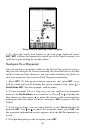
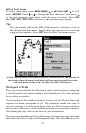
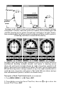
Trails
A trail, or plot trail, is a string of position points plotted by the Cuda
240 as you travel. It's a travel history, a record of the path you have
taken. Trails are useful for repeating a journey along the same track.
They are particularly handy when you are trying to retrace your trip
and go back the way you came. On the screen, trails are represented by
a flashing line extending from the back of the current position arrow.
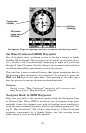
Creating and Saving a Trail
The Cuda 240 is set at the factory to automatically create and record a
trail while the unit is turned on. The unit will continue recording the
trail until the length reaches the maximum trail point setting (default is
2,000, but the unit can record trails 9,999 points long). When the point
limit is reached, the Cuda 240 begins recording the trail over itself.
By default, the trail flashes once a second, making it easier to see
against the plotter's background. With the default auto setting, the
Cuda 240 creates a trail by placing a dot (trail point) on the screen
every time you change directions. (The methods used for creating a trail
and the trail update rate can both be adjusted or even turned off. See
Sec. 8 for Trail Options.)
To preserve a trail from point A to point B, you must "turn off" the trail
by making it inactive before heading to point C or even back to point A.
When the current trail is set inactive, the Cuda 240 automatically cre-
ates and begins recording a new trail.