


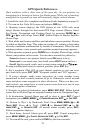
83
Find Distance From Point to Point
You can also measure distance between two other points on the plotter.
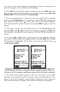
1. While on the Plotter Page press:
MENU|↓ to FIND DISTANCE|ENT.
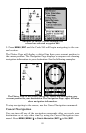
2. Center your cursor over the first position. (A rubber band line ap-
pears, connecting your current position to the cursor's location.) Press
ENT to set the first point, and the rubber band line disappears.
3. Move the cursor to the second position. The rubber band line reap-
pears, connecting the first point you set to the cursor. The distance
along that line will appear in the information box at the bottom of the
screen.
4. Press
EXIT to clear the command and return to the page screen.
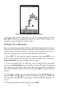
Waypoints
A waypoint is simply an electronic "address," based on the latitude and
longitude of a position on the earth. A waypoint represents a location,
spot, or destination that can be stored in memory, then be recalled and
used later on for navigation purposes.
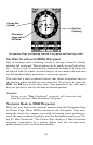
Create a Waypoint
You can create a waypoint at the cursor position on the plotter, or at
your current position while you are navigating. You can create a way-
point at any location by manually entering the position's latitude and
longitude.
NOTE:
To create and save a Waypoint, these first two techniques use the
Quick Save method, the fastest and easiest way to create a waypoint.
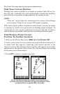
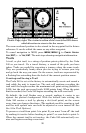
Create Waypoint at Current Position
While you are traveling, press WPT|WPT. The waypoint is saved and
automatically given a name with a sequential number, such as "way-
point 003." The waypoint symbol and number appear on the plotter.