


30
steer left to return to the desired course. You can use the
ZIN or ZOUT
keys to change the cross track error range.
Travel Time is the time that it will take to reach your destination at
your present closing speed. You can also customize the time data box to
show Arrival Time instead. Arrival Time is the local time it will be
when you arrive at the destination, based upon your present closing
speed and track.
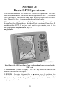
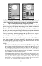
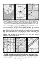
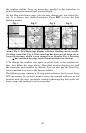
In the preceding figure, the driver is headed northwest (a 307º track)
toward a waypoint 307º (bearing) away. The cross track error range
(white corridor) is 0.20 miles either side of the course. The driver is
headed toward trail waypoint 002, which is 5.65 miles away. Traveling
at a speed of 70 mph, the driver will arrive at the waypoint in 3 min-
utes, 24 seconds.
The Navigation Page has its own menu, which is used for some ad-
vanced functions and for setting various options. To access the Naviga-
tion Page Menu, from the Navigation Page, press
MENU.
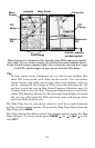
Map Page
The Map Page screens show your course and track from a "bird's-eye"
view. By default, this unit shows the map with north always at the top
of the screen. (This can be changed. See the topic Map Orientation, in
Sec. 5.) If you're navigating to a waypoint, the map also shows your
starting location, present position, course line and destination. You
don't have to navigate to a waypoint, however, to use the map.
Map Page is the default screen that appears when you turn on the unit.
To get to the Map Page from another page: Press
PAGES|→ or ← to
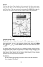
MAP|EXIT. When the Map Page is displayed, a screen similar to the fig-
ures on the next page appears.
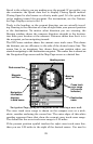
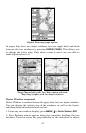
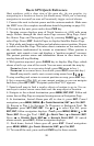
The arrow in the center of the screen is your present position. It points
in the direction you're traveling. The solid line extending from the back
of the arrow is your plot trail, or path you've taken.
The map zoom range is the distance across the screen. This number
shows in the lower left corner of the screen. In the first of the following
example figures, the range is 4,000 miles from the left edge of the map
to the right edge of the map.
The Zoom In and Zoom Out keys zoom the map to enlarge or reduce its
coverage area and the amount of mapping detail shown. There are 40
available map zoom ranges, from 0.02 miles to 4,000 miles.