43
3. Press → to
LATITUDE|ENT. Enter the latitude by pressing ↑ or ↓ to
change the first character, then press → to the next character and re-
peat until the latitude is correct. Press
ENT.
4. Press ↓ to
LONGITUDE|ENT. Enter the longitude by pressing ↑ or ↓ to
change the first character, then press → to the next character and repeat
until the longitude is correct. Press
ENT, then EXIT|EXIT to return to the
previous page display. The waypoint is saved and automatically given a
name with a sequential number, such as "waypoint 001." The waypoint
symbol and number appear on the map and in the waypoint list.
Navigate To a Waypoint
You can select any waypoint visible on the Map Page with the cursor,
then use the Navigate to Cursor command (we will describe how later
in this section.) You can avoid scrolling the map to pick your waypoint
if you use the Find Waypoint commands.
1. Press
WPT|↑ to MY WAYPOINTS|ENT. To look up the nearest waypoint,
press ↓ to
NEAREST | ENT. To look by name — and scroll through the en-
tire waypoint list — press ↓|
ENT. For this example, let's look by name.
2. If your waypoint list is a long one, you can spell out the waypoint name
in the
FIND BY NAME box. Press ↑ or ↓ to change the first character, then
press → to move the cursor to the next character and repeat until the
name is correct, then press
ENT to jump to the list below.
3. If the list is short, you can jump directly to the
FIND IN LIST box by
pressing
ENT. Use ↑ or ↓ to select the waypoint name, press ENT and the
waypoint information screen appears with the
GO TO command selected.
4. To begin navigating to the waypoint, press
ENT.
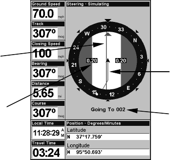
Navigating to waypoint 002 and leaving a trail
Destination
name
Trail line
(magenta)
Course line
(red)
Off course
range, set at
0.20 mile
