


76
GPS Simulator
The GPS simulator simulates real world navigation. It is a great way to
practice using your unit. You can set the starting location by entering
latitude/longitude or from a stored waypoint, map place or POI location.
You can steer the position arrow and change speed on the map by using
the arrow keys —
STEER WITH ARROWS command — or by setting the track
and speed in the dialog boxes provided on the simulator menu screen.
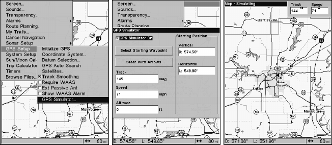
To get to the GPS Simulator:
1. Press
MENU|MENU|↓ to GPS SETUP|ENT.
2. Press ↓ to
GPS SIMULATOR|ENT. The GPS Simulator Menu appears.
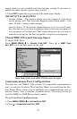
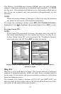
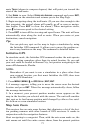
GPS Setup Menu (left). GPS Simulator menu (center).
Map Page showing Steer with Arrows dialog boxes (right). The trav-
eler is following a track of 144º at a speed of 71 miles per hour.
Choose the desired settings, then turn on the simulator by highlighting
the
GPS SIMULATOR ON box and pressing ENT. Press EXIT repeatedly to get
back to the main page display. A message and tone appear periodically
to remind you the simulator is on. To turn off the simulator, repeat the
steps above or turn off the unit.
If you selected the Steer with Arrows command and want to remove the
dialog boxes from the screen, press
EXIT. That will clear the track and
speed boxes without disrupting the simulation and allow you to use the
map cursor.
Simulating Trail or Route Navigation
In Simulator mode, your unit can automatically follow a trail or route
without manual steering if you use these steps:
1. From the Map Page, go to the simulator menu. Pick a
STARTING
POSITION at or near the beginning of your trail/route. Enter an approxi-