


1. OPERATION
15
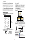
1.18.2 Editing a registered waypoint
1. Press the MENU/ESC key to open the menu.
2. Use
S or T to choose Data and press the
ENTER key.
3. Use
S or T to choose WPT List and press
the ENTER key.
4. Use
S or T to choose a waypoint to be
edited and press the ENTER key.
The Edit Waypoint window is shown.
5. Use
S or T to choose item desired and
press the ENTER key.
6. Edit latitude and longitude, similar to how
you entered the waypoint name.
7. Press the MENU/ESC key four times to close
the window.
1.18.3 Erasing waypoint
To erase a waypoint do the following:
1. Do steps 1 through 4 in 1.18.2.
2. Use
T to choose the Erase? and press the
ENTER key.
3. Use
S to choose Yes and press the ENTER
key.
4. Press the MENU/ESC key three times to
close the window.
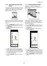
1.18.4 Setting destination waypoint
Set a destination waypoint to find range, bearing
and time-to-go to that point. Range, bearing
and time-to-go (to the waypoint) are shown on
the nav data display. See next section for
details.
1. Press the MENU/ESC key to open the menu.
2. Use
S or T to choose Data and press the
ENTER key.
3. Use
S or T to choose Go to WPT and press
the ENTER key.
4. Use
S or T to choose a destination way-
point and press the ENTER key.
5. Press the MENU/ESC key twice to close the
window.
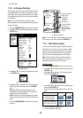
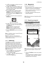
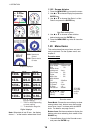
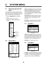
1.19 Setting Up Nav Data
Displays
The user may arrange the nav data displays as
desired.
1.19.1 Nav data displays
1. Rotate the MODE knob to choose NAV1 or
NAV2.
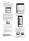
Nav Data setting window
Note: The setting window disappears if there is
no operation for five seconds. In this case press
the TrackPad to re-display the window.
2. Use
S or T to choose a data display
window desired.
3. Use
W or X to choose item to display.
Items displayable depend on the screen divi-
sion.
4. Press the ENTER key.
S
/
T
: Window Selection
W
/
X
: Data Selection
[ENTER] : Set
[MENU] : Cancel
Two-data
display
Three-data
display
Four-data
display
(1)
(2)
(3)
(4)
(5)
(6)
(7)
(8)
(9)
I
tems displayable in (1) - (3): speed (STW)
*,
w
ind speed and direction*, destination
w
aypoint data*, compass*, heading*, depth
,
p
osition, course, range and bearing,
t
rip meter, odometer, water temperature,
a
ir pressure, time-to-go to destination
w
aypoint, XTE*, speed (SOG)*
I
tems displayable in (4) - (9): depth, positio
n,
s
peed (SOG), speed (STW), course,
r
ange and bearing, trip meter, odometer,
w
ater temperature, heading, wind speed,
w
ind direction, air pressure, time-to-go to
d
estination waypoint, XTE
*
= Graphic display