


7. Vector Charts
7-53
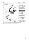
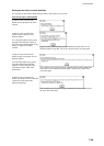
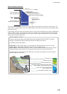
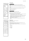
TWO-COLOUR presentation:
Non-navigable area
Chart zero
Shallow contour
Safety contour (input value)
Deep contour
Safety contour (exisiting in ENC)
Navigable area
Safety
depth
Soundings within this
range are highlighted.
Soundings within this
range are not highlighted.
In the two-colour presentation unsafe water is shown as blue colour and safe water shown as white colour. The
safety contour is used to qualify unsafe water (depth shallower than safety contour) and safe water (depths deeper
than safety contour).
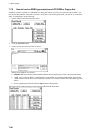
If input Safety contour does not exist in electronic chart, system selects automatically next deeper available depth
contour as Safety contour. For example input value is 8 m, but there is no 8 m depth contour in electronic chart,
system selects next deeper depth contour (10 m) as Safety contour. Depth contour value of 10 m is presented as
Safety Contour in this electronic chart.
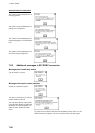
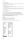
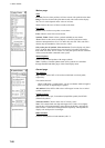
Chart zero (0 m)
Chart zero (0 m)
Shallow water (5 m)
Shallow water (5 m)
Ship’s safety depth (10 m)
Ship’s safety depth (10 m)
Obstruction of depth less than the safety contour
which lies within the safe water area (15 m)
Obstruction of depth less than the safety contour
which lies within the safe water area (15 m)
Safety contour value setting specified
by the mariner (17 m)
Safety contour value setting specified
by the mariner (17 m)
If not available next deeper (30 m)
If not available next deeper (30 m)
0
0
5
5
10
10
16
16
30
30
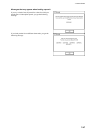
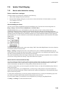
The figure displays the different water depth limits for the navigation by ENC in ECDIS. The ship's
navigator can individually adjust the warning time before reaching such limit line.
The following settings are possible:
Safety depth: A defined water depth, e.g. the draught and underkeel clearance, which are used by
ECDIS to display water-depths, which are equal or lower as the depth defined.
Safety contour: A defined water-depth area, which is used by ECDIS to differentiate between safe and
unsafe water-depth and to generate an anti-grounding alarm before the ship is passing the line.
If the ENC data do not provide the chosen depth-lines, the system automatically uses the next deeper
available depth-line as reference.
Anti-grounding function