


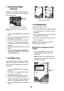

17
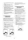
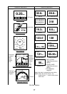
GRAPHIC DISPLAYS DIGITAL DISPLAYS
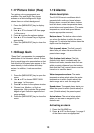
1 0.5 0 0.5 1
Wpt 03
Rng 0.19nm Brg 321°
XTE 0.00nm Cse 333°
DESTINATION WAYPOINT GRAPHIC
XTE
scale
Bearing,
Course
Destination
waypoint
direction
Destination
waypoint
data:
Name,
Range,
XTE
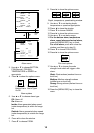
Wind APP*
WIND GRAPHIC
60
120
90
0
30
150
180
120
150
90
60
30
120°
Speed
10.3
m/s
COMPASS GRAPHIC
SPEED GRAPHIC
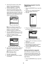
17.2
Speed
20
50
40
60
30
10
0
Course
123.0
°
COURSE
Depth
32.8ft
DEPTH
Heading TRUE/MAG#
318
°
HEADING
Odometer
56nm
ODOMETER
Position
30° 00.065'N
130° 00.574'E
POSITION
Temperature
69.8°F
WATER TEMPERATURE
Trip meter
121nm
TRIP DISTANCE
Time to Go
00H30M
TIME-TO-GO&
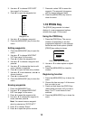
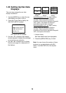
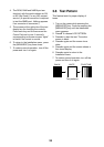
1 0.5 0 0.5 1
0.25nm
XTE
XTE GRAPHIC
1018
hpa
AIR PRESSURE
Air Pressure
Speed
19.3kt
SPEED
Rng
1.21
nm
RANGE & BEARING&
Brg
140
°
Wind Speed APP*
8.0m/s
WIND SPEED
Wind Dir. APP*
138
°
WIND DIRECTION
kt
Bearing to
destination
waypoint
Course
Brg
30°
Cse
90°
N
E
* APP or TRUE
depending on menu
setting.
# TRUE or MAG
depending on menu
setting.
&To destination
waypoint
XTE scale
Speedometer
Note 1: Nav data is updated with some delay.
Note 2: When data is lost 120 sec., the
display shows "- -" at the location where
data is lost.
Nav data displays