


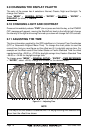
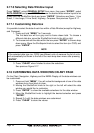

Page 26 GPS Chart 150C
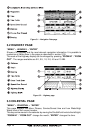
Figure 3.1 - Navigation Data page
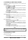
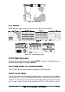
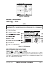
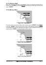
3.2 HIGHWAY PAGE
“MENU” + HIGHWAY + “ENTER”
Shows a 3D Highway and the most relevant navigation information. It is possible to
customize all fields show in the page as described in section 2.18.
The scale of the Highway display can be changed by pressing “ZOOM IN” / “ZOOM
OUT”. The ranges available are 0.2, 0.5, 1.0, 2.0, 4.0 and 10 NM.
Figure 3.2 - Highway page
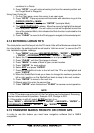
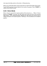
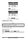
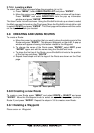
3.3 CELESTIAL PAGE
“MENU” + CELESTIAL + “ENTER”
This page displays the Moon Phases, Sunrise/Sunset time and Low Water/High
Water level at the current location.
The day can be moved in the calendar by moving the ShuttlePoint knob to the left/right;
“ZOOM IN” / “ZOOM OUT” change the month; “ENTER” changes the time.