


Page 66 GPS Chart 150C
3.15.4.9 Simulation
Allows simulating Vessel Position, speed and course.
The simulated path is generally a straight course starting from the current position
assumed by the cursor at the Simulation activation time.
Simulation Mode: Enables (On) or disables (Off) the Simulation. The default
setting is Off.
Course: Sets the desired value for heading in Simulation mode. The default
setting is 000° M.
Speed: Sets the value for speed in the Simulation mode. The default setting is 01.0
Kts.
Date: Sets the date of the simulated fix. Inserts date using the ShuttlePoint knob.
Time: Sets the time of the simulated fix. Inserts time using the ShuttlePoint knob.
Cursor Control: Enables (On)/disables (Off) the cursor control. The default
setting is Off.
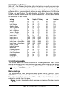
3.15.5 Automatic Info
The type of Automatic Info is user selectable. The possible settings are:
- Off: disabled, no automatic info shown at all.
- On Points: only on points. This is the default setting.
- On All: on all objects (points, lines and areas).
The Automatic Info On Points shows information when the cursor is placed on
points (as Port Services, Tides, lights, wrecks, rocks, buoys, beacons, obstructions,
land markers, etc.). The Automatic Info On All shows information when the cursor is
placed on points, on lines (as Depth contours, Traffic Separation, Territorial Sea,
Cartographic Lines etc.) on areas (Depth, Built-up, Sea, Attention, Restricted etc.) and
on names (on the beginning of the text -hot spot- or on any of the characters of the
name -name message box-).
The details on Land, Source of Data, Cartographic Area and Spot Soundings
are not shown.
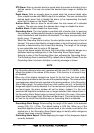
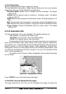
Figure 3.15.5 - Automatic Info on Points
Press “ENTER” to see information about that object.
3.15.5.0Info Tree and Expanded Info pages
This page combines the Info Tree and the Expanded Info pages; this gives the