


GPS Chart 150C Page 61
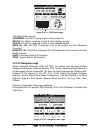
Land Settings
The Land Settings menu controls the level of cartographic details shown.
Rivers & Lakes: Enables / Disables the display of Rivers and Lakes. The default
setting is On.
Natural Features: Enables / Disables the display of the Natural Features (any
topographic feature formed by the action of natural process e.g. coastlines,
relief…). The default setting is On.
Cultural Features: Enables / Disables the display of the Cultural Features (any
man-made topographic features e.g. built-up area, roads…). The default setting
is On.
Landmarks: Enables / Disables the display of the Landmarks (any prominent
object such as monument, building, silo, tower, mast,… on land which can be
used in determining a location or a direction). The default setting is On.
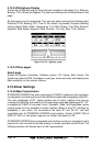
Chart Settings
The Chart Settings menu controls the details shown from a C-MAP C-CARD.
Lat/Lon Grid: Enables / Disables the display of the Latitude and Longitude grid.
The default setting is On.
Chart Boundaries: Enables / Disables the display of the Chart Boundaries. Auto
setting instead, allows showing only boundaries for the next four charts contai-
ned on the C-CARD. The default setting is On.
Cartography: Enables / Disables the Cartography. The default setting is On.
Used to zoom-in and pan everywhere regardless the existence of data. While
in "virtual cartography" (Cartography Off), by setting Cartography On from
menu, the chart plotter displays the previous scale level with charts. Again while
in Cartography On, the chart plotter will work in the same way also when you exit
from the charts coverage, panning with the cursor or because of a ship position
change. When in Cartography Off, it is also possible to have virtual cartography
between two subsequent scale levels with charts.
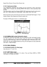
Mixing Levels: Enables / Disables the Mixing Levels. The default setting is Off.
When the map coverage at the current zoom level does not fill the entire screen,
the chart plotter draws the rest of the map expanding the cartographic informa-
tion read from, at most, two zoom levels above the current zoom level. For this
reason the map is drawn three times: firstly it draws the two levels before the
current level and then the current level. The area covered by the cartographic
data read from the previous levels is identified by a dotted pattern. When the
cursor is moved on an area not covered by data of the current level and the
Cartography item is switched Off, the chart plotter zooms out to the first level
covered by cartographic data. When the Cartography item is switched On, the
cursor can be moved on the areas obtained from the previous levels but no
information is provided on the objects found on that area since it is considered
not suitable for navigation at that scale level.
NOTE
The Mixing Levels function works only with the new NT
+
C-CARDs. It also affects
the speed of the redraw of the screen. If this function is not used it maybe disabled.