


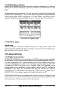

Page 58 GPS Chart 150C
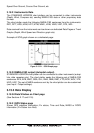
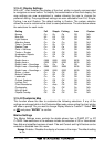
3.15.3.33D Highway Display
Shows the 3D highway and the most relevant navigation information (E.g. Distance,
Bearing, TTG, Course, and Speed). The user can customize all six fields shown on the
page.
All data pages can be customized. The user can select amongst the following data:
Distance To Go, Bearing, XTE, Time To Go, Depth, Log Speed, Compass Heading,
Velocity Made Good, Water Temperature, True Wind Speed, True Wind Direction,
Apparent Wind Speed, Apparent Wind Direction, Trip Log, Date, Time, Altitude.
Figure 3.15.3.3 - Highway page
3.15.3.4Other pages
About page
Shows the System information: Software version, NT
+
Library, Bios, Kernel, File
System and Internal GPS. Cartridges in use (type, name and code) and displays user
data availability on the internal memory.
3.15.4User Settings
3.15.4.0Map Customization
STANDARD HORIZON has taken advantage of C-MAP’s experience with professio-
nal navigation, by allowing the use of the refined and improved cartography called NT
+
.
The new cartography of NT
+
makes creative use of colors, patterns and icons to
increase the familiarity and usability of the much larger coverage database of NT
+
. NT
+
is supplied by C-MAP in four sizes: Local
+
, Standard
+
, Wide
+
and SuperWide
+
(some
product types are only available in certain markets. Refer to local NT
+
catalogs for
availability in your area). For convenience the older NT and the NT
+
are both
compatible with all STANDARD HORIZON chart plotters. Contact C-MAP USA at
(508) 477-8010 or visit www.c-map.com for further information on NT
+
.
STANDARD HORIZON has incorporated new functions to aid your navigation and to
improve the look and feel of the data display to closely resemble actual Charts. The
following sections will discuss each of the improvements.