


GPS Chart 150C Page 55
- Activate the navigation (assign the Destination) to the selected User Point.
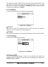
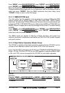
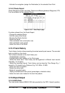
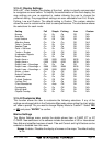
3.15.0.7Route Report
Shows Waypoints position and label, Distance and Bearing between Waypoints, ETE,
Fuel consumption of the selected Route.
Figure 3.15.0.7 - Route Report page
Functions allowed from the Route Report:
- Change the selected Route.
- Edit the name of the Route.
- Reverse the Route direction.
- Delete the Route.
- Enter estimated fuel consumption rate.
- Enter estimated cruise speed.
- Select the color of the Route.
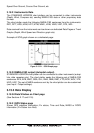
3.15.1Track History
Track History function allows recording the actual vessel’s past course. The recorded
track is plotted on the charts.
The functions allowed on the track history are:
- Enable/Disable recording.
- Enable/Disable track display on the Chart page.
- Select the active track: Track history can be organized in different track records
(Normally 1 to 5 tracks).
- Select the recording interval: Track history can be stored by Time Range (E.g. 1
second to 10 minutes) or by Distance (E.g. 0.01 NM to 10 NM).
- Select the track line pattern..
- Delete the active track.
- Delete all recorded tracks.
- Display available/used track points (percentage or absolute value).
- Select the track color instead of the track line pattern.
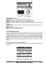
3.15.2Input/Output
3.15.2.0GPS Data
The chart plotter outputs NMEA-0183 data provided by the GPS: Vessel’s position,