


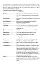
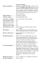
4
Sonar Sounding
Depth capability:........... SeaCharter 642cDF iGPS: 1,500 feet (457
meters). FishElite 642c iGPS: 800 feet (244
meters). Actual capability depends on trans-
ducer configuration and installation, bottom
composition and water conditions. All sonar
units typically read deeper in fresh water
than in salt water.
Depth display:................ Continuous display .
Audible alarms: ............. Deep/shallow/fish/zone.
Automatic ranging:....... Yes, with instant screen updates.
Auto bottom track:........Yes.
Zoom bottom track: ...... Yes.
Split-screen zoom:.........Yes.
Surface water temp:..... Yes.
Speed/distance log:...... Optional (requires optional speed sensor).
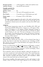
GPS
Recording:........................MMC & SD cards for recording GPS trip de-
tails and displaying charts or custom maps.
Receiver/antenna:......... Internal; Built-in 12 parallel channel
GPS/WAAS.
Background map:.......... Built-in custom, detailed Eagle map. Con-
tains: enhanced detail of continental U.S.
and Hawaii. Includes more than 60,000 nav
aids and 10,000 wrecks/obstructions in
coastal and Great Lakes waters. Metro
areas, selected major streets/highways and
interstate exit services details included.
Custom mapping:.......... MapCreate
6 software optional; optional
plug and play LEI FreedomMaps offer the
same high-detail without the computer work
of MapCreate. Other plug and play mapping
options include FreedomMaps, Fishing Hot
Spots
Elite, LEI NauticPath charts,
LakeMaster
ProMaps and Navionics
charts.
Mapping memory:......... Up to 1 gigabyte on one MMC (or SD) card.
Position updates: .......... Every second.