


136
To configure a map fix:
To use this format, you need to follow these steps in order. Take a map
of the area and determine a reference latitude/longitude.
NOTE:
In order for this system to work, the latitude/longitude lines must
be parallel with the edge of the map. USGS maps are parallel, oth-
ers may not be. Also, this works better with smaller scale maps,
such as 1:24000.
The reference position can be anywhere on the map, but the closer it is
to your location, the smaller the numbers you will be working with.
Once you have decided on a reference position, you can save it as a way-
point. See the waypoint section for information on saving a waypoint.
Save the reference position as a waypoint. Exit the waypoint screens.
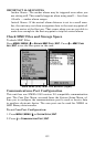
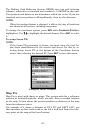
1. Press
MENU|MENU|↓ to GPS SETUP|ENT.
2. Press ↓ to
COORDINATE SYSTEM|ENT.
3. Press ↓ to
SETUP MAP FIX|ENT.
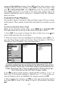
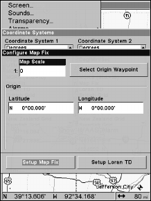
The screen below appears, and
MAP SCALE is highlighted. Press ENT and
enter the map's scale. This is generally at the bottom of the paper map.
It's shown as a ratio, like 1:24000. Press
EXIT and the unit returns to
the Configure Map Fix screen.
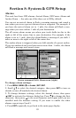
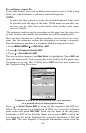
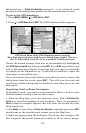
Configure a map fix so the unit can find your position
on a printed chart or topographical map.
Press → to SELECT ORIGIN|ENT to bring up the waypoint and POI list.
Select the waypoint (or a landmark of POI) you saved the reference
point under and press
ENT|ENT. Spell out the name of the waypoint,
landmark or POI in the Find By Name box or press
ENT to select the
item from the list below. Highlight the waypoint, landmark or POI and
press
ENT. The unit displays a waypoint information screen with the