


142
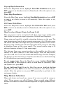
Pop-up Map Information
From the Map Data menu, highlight
POPUP MAP INFORMATION and press
ENT to turn it on (check) or turn it off (uncheck). After the option is set,
press
EXIT.
Draw Map Boundaries
From the Map Data menu, highlight
DRAW MAP BOUNDARIES and press ENT
to turn it on (check) or turn it off (uncheck). After the option is set,
press
EXIT.
Fill Water With White
From the Map Data menu, highlight
FILL WATER WITH WHITE and press
ENT to turn it on (check) or turn it off (uncheck). After the option is set,
press
EXIT.
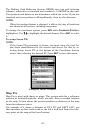
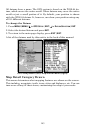
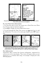
Map Overlays (Range Rings; Lat/Long Grid)
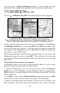
The map screen can be customized with four range rings and/or grids
that divide the map into equal segments of latitude and longitude.
Range rings are handy for visually estimating distances on the map. The
ring diameters are based on the current zoom range. At a 100-mile zoom,
the screen will show two rings with your current position in the center.
The large ring touching the left and right sides of the screen is 100 miles
in diameter (same as the zoom range). The second smaller ring is 50
miles in diameter (always 1/2 the zoom range).
The distance from your current position to the smaller ring (the ring's
radius) is 25 miles (always 1/4 the zoom range). With the map cursor,
you can scroll over to see the third and fourth rings. In this example,
the distance to the third ring is 75 miles and distance to the fourth ring
is 100 miles from your current position.
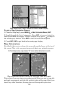
To set range rings: From the Map Data menu, highlight
RANGE RINGS
and press ENT to turn them on (check) or turn them off (uncheck). After
the option is set, press
EXIT.
To set Lat/Long Grid: From the Map Data menu, highlight
LAT/LON
GRID LINES and press ENT to turn them on (check) or turn them off (un-
check). After the option is set, press
EXIT repeatedly to get back to the
main page display.
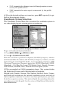
Map Datum Selection
Maps and charts are based on a survey of an area covered by a map or
chart. These surveys are called Datums. Maps created using different
datums will show the same latitude/longitude in slightly different loca-
tions.