


110
To stop navigating to the cursor, use the Cancel Navigation command.
Press
MENU|MENU|↓ to CANCEL NAVIGATION|ENT|← to YES|ENT. The unit
stops showing navigation information.
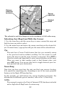
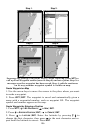
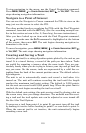
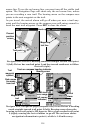
Navigate to a Point of Interest
You can use the Navigate to Cursor command for POIs in view on the
map, just use the cursor to select the POI.
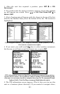
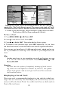
The other method involves searching for POIs with the Find Waypoint
command, launched with the
WPT key. (See the searching example ear-
lier in this section or turn to Sec. 9, Searching, for more instructions.)
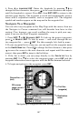
After you have looked up an item with the Find Waypoint command,
use ← → to make sure the
GO TO command is highlighted at the bottom
of the screen, then press
ENT. The unit begins showing navigation in-
formation to the item.
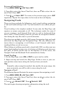
To cancel navigation, press
MENU|MENU|↓ to CANCEL NAVIGATION|ENT|←
to
YES|ENT. The unit stops showing navigation information.
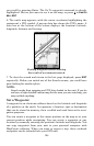
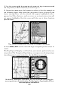
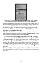
Creating and Saving a Trail
A trail or plot trail, is a string of position points plotted by the unit as you
travel. It is a travel history, a record of the path you have taken. Trails
are useful for repeating a journey along the same track. They are par-
ticularly handy when you are trying to retrace your trip and go back the
way you came. On the screen, trails are represented by a solid line ex-
tending from the back of the current position arrow. The default color is
light magenta.
The unit is set to automatically create and record a trail when it is
turned on. The unit will continue recording the trail until the length
reaches the maximum trail point setting. The default is 2,000 points,
but the unit can record trails 9,999 points long. When the point limit is
reached, the unit begins recording the trail over itself.
With the default auto setting, this unit creates a trail by placing a dot on
the screen every time you change directions. The methods used for creat-
ing a trail and the trail update rate can be adjusted or even turned off.
See Sec. 8 for Trail Options.
To preserve a trail from point A to point B, you must turn off the trail
by making it inactive before heading to point C or even back to point A.
When the current trail is set inactive, the unit automatically begins
recording a new trail.