27
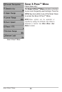
What’s on the Side Imaging® Display
accurate interpretation of bottom contour and structure. For Side Imaging®, the
rock and gravel provide a clearer sonar return than mud and sand because
better than downward slopes that face away from the transducer. You can find a
for accurate interpretation of bottom contour and structure, including the
Topography Changes - The light part of the
display shows where the beam is hitting hard
bottom or rising terrain. The dark part of the
display indicates soft bottom (sand, mud) or
descending terrain.
Shadows result from a lack of reflected sonar
from a particular area and can be as valuable
for interpretation than the sonar reflected by
the object itself. Use shadows to help you see
the image in 3 dimensions, oriented in space.
You can gain insight into the actual shape of
an object, or the depth to which it has sunk
into the bottom, through shadows on the
display. Objects standing on the bottom cast
a sonar shadow. The longer the shadow, the
taller the object. Fish also cast shadows. You
can use the shadow to interpret how close
the fish is to the bottom.
Side Imaging® Range - Images shown on the
right side of the screen are located on the
right side of your boat, and images shown on
the left side of the screen are located on the
left side of your boat. In this illustration, the
sonar is pinging 120 feet on each side.
NOTE: Entries in this view that list (with
Temp/Speed or GPS Receiver) are available
if either device is connected to the
Fishfinder. If both devices are connected,
then only the information from the GPS
receiver will be displayed on the view.