


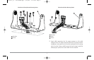
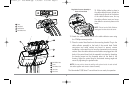
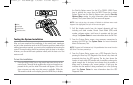
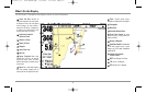
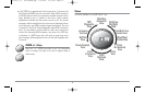

What’s On the Display
The 900 Series™ Chartplotter can display a variety of useful information.
15
1
2
3
4
5
6
7
8
9
10
11
12
13
14
15
16
17
18
19
20
Cursor Info Box: indicates the
Latitude and Longitude of the cursor position,
the distance to travel to the cursor position
and the bearing to the cursor position is
shown with a GPSreceiver. A waypoint can
be marked at the cursor position for later
retrieval and use with a GPS receiver.
Latitude and Longitude
Position of Cursor
Distance to Cursor
Bearing to Cursor
Waypoint
Active Cursor Icon
Boat Icon
Course Projection Line: Arrow
extending from the bow of the boat that
projects your current course, and shows
where the boat will go if you continue on your
present course.
Route: Two or more linked waypoints
that show intended navigation and the
shortest path from one waypoint to the next.
9
8
7
6
5
4
3
2
1
Track: Detailed position history,
displayed as a breadcrumb trail of trackpoints.
Cartography
Map Scale
Selectable Readout Boxes
Course Over Ground: the current
direction the boat is traveling measured in
degrees from North.
Bearing to Waypoint
Speed Over Ground:the measurement
of the boat’s progress across a given
distance, and is the speed measurement
provided by GPS.
Latitude and Longitude
Position of Boat
NEXT: Next Waypoint in the Route
TTG: Time to Go to Waypoint
DTG:Distance to Go to Waypoint
20
19
18
17
16
15
14
13
12
11
10
531569-1_B - 955c ManE.qxp 3/4/2007 5:03 PM Page 15